About Green Tracks - hiking partner
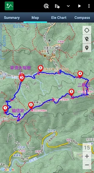
The core function of Green Tracks reads and analyzes the GPX, KML, KMZ and other track files in the mobile phone, and draws the analyzed content on the map. With the GPS satellite positioning, the user can know where he...
The core function of Green Tracks reads and analyzes the GPX, KML, KMZ and other track files in the mobile phone, and draws the analyzed content on the map. With the GPS satellite positioning, the user can know where he is in the track line. Reduce the risk of getting lost and can be used as a reference for outdoor activities such as mountain climbing and hiking.
•Supports Mapsforge offline map files
You can download the OpenAndroMaps world map directly in Green Tracks.
•Offline search
Install Mapsforge's POI file to search for points of interest offline.
•Supports offline maps in MBTiles format
Users can use Mobile Atlas Creator (MOBAC) to create MBTiles offline maps and select the MBTiles SQLite format. For offline map production methods, please refer to https://sky.greentracks.app/?p=2895
•Online map
You can use Google Road Map, Google Satellite Map, Google Hybrid Map, Google Terrain Map.
•Record tracks
Use Green Tracks to record your own journey. The recorded track lines can also be edited or merged, and the records can be saved in file formats such as GPX, KML or KMZ through the export function.
•Supports various types of track file formats
Green Tracks can parse track files in GPX, KML, KMZ and other file formats and display them on the map.
•Route planning
Supports BRouter, you can plan routes in Green Tracks and export them as GPX, KML or KMZ.
•Automatically return coordinates
By automatically returning coordinates or manually returning coordinates (network signal is required), those left behind can keep track of the traces at any time.
•Mark location
The coordinates reported by family members or friends can be marked on the map automatically or manually, making it easier to track their whereabouts.
•Coordinate conversion
WGS84 coordinate format conversion and TWD67, TWD97, UTM and other geodetic datum conversions.
•Off-track Alarm
During the process of recording the track, combined with the GPX file, you can use this function to avoid taking the wrong path.
•Backup and restore
Backup and restore self-recorded track records.
•Backup track files
Use "Backup" to compress all GPX, KML, KMZ and other types of files in your phone into .zip files for easy replacement of new phones or sharing with other users. nnThe backed up .zip file can be decompressed through the file management on the phone, or decompressed to the /Download/GTs/ folder on the phone through "Restore".
•Support HGT files
The HGT elevation file can be used to correct the altitude and improve the accuracy of the altitude.
•Photo map
Scan the photos on your phone and display them on the map to recall all the memories you took when you took them.
•Share your tracks
You can share your GPX records with other users, or download GPX files for tracking.
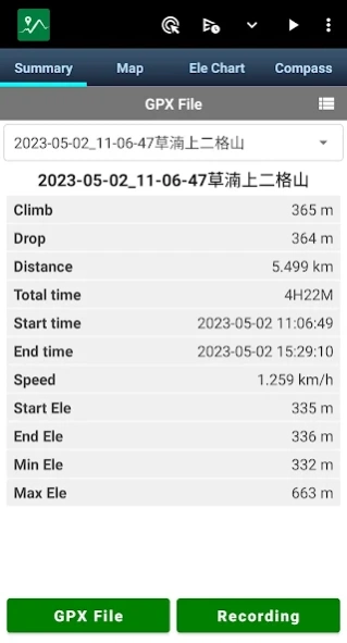
• Screenshot
Take screenshots of the "Summary", "Map" and "Ele Chart" of the walking track and collage them into one photo for easy sharing on various online platforms.
•Supports overlapping maps
Green Tracks supports offline maps stacked on top of online maps, and offline maps stacked on top of offline maps.
•Supports Google Earth tour files
The records of the Green Tracks can be exported to kml or kmz files and provided with Google Earth Pro version (PC version) to record dynamic track videos. Video reference
https://youtu.be/f-qHKSfzY9U?si=MO7eQQVSHEyZ57DK
Our website
https://en.greentracks.app/
Previous Versions
Here you can find the changelog of Green Tracks - hiking partner since it was posted on our website on 2016-10-12 14:33:02.
The latest version is 10.7.1 and it was updated on 2024-04-23 10:45:10. See below the changes in each version.
Green Tracks - hiking partner version V10.7.1
Updated At: 2024-04-07
Changes: 1.Get rewards for watching videos. Watch a few rewarded ads in exchange for an ad-free period.
2.Other bug fixes.
Green Tracks - hiking partner version V10.6
Updated At: 2024-03-18
Changes: 1.Following function of "share gpx file".
2.The "Automatically return coordinates" message contains battery level.
3. Remove the "All files access" permission (MANAGE_EXTERNAL_STORAGE)
Green Tracks - hiking partner version V10.5
Updated At: 2024-02-13
Changes: 1. Adjust the "share gpx file" preview screen.
2.Select the file interface to synchronize, including "Open track file", "Share gpx file" and export "My track record".
3. A elevation chart is added to the lower left corner of the Google Earth tour file.
4. If you long click the map to add a waypoint when editing records, the waypoint time will be taken from the time of the track point within 10 meters from the track line.
5. A new timing format is added to the default name of the waypoint.
Green Tracks - hiking partner version V10.3.1
Updated At: 2024-01-20
Changes: 1.Support kml 2.2 specification.
2. Can export kml and kmz tour files that can be played by Google Earth Pro (PC version).
Green Tracks - hiking partner version V10.2
Updated At: 2023-12-20
Changes: 1. Adjust the "Open track file" user interface from "Global settings".
2. Back up and restore the track files in your phone.
3. Fix the crash issue when recording track on Android 14 mobile phones.
Green Tracks - hiking partner version V10.1
Updated At: 2023-10-31
Changes: 1. Parse and display Polygon of KML files on the map.
2. Fixed the problem that GPX files shared by other apps cannot be opened.
3. Other bug fixes.
Green Tracks - hiking partner version V10.0.2
Updated At: 2023-10-19
Changes: 1. When recording the track, record whether there is a network signal at each track point.
2. The communication point and indicator switching icon is displayed on the right side of the map.
3. In the global settings, select whether the exported GPX file includes communication points.
4. The list of shared gpx files shows the GPX recording date.
5. Fixed the problem that the photo map cannot be opened on Android 13 mobile phones.
6. Other bug fixes.
Green Tracks - hiking partner version V10.0
Updated At: 2023-10-09
Changes: 1. When recording the track, record whether there is a network signal at each track point.
2. The communication point and indicator switching icon is displayed on the right side of the map.
3. The list of shared gpx files shows the GPX recording date.
4. Other bug fixes.
Green Tracks - hiking partner version V9.20
Updated At: 2023-08-08
Changes: 1. Fine-tune the function of exporting GPX files.
2. Fix the problem of exporting KML files.
3. System performance optimization.
4. Other bug fixes.
5. Remove "MANAGE_EXTERNAL_STORAGE" Permission.
Green Tracks - hiking partner version V9.18.9
Updated At: 2023-08-05
Changes: 1. Require notification permissions for Android 13 phones
2. Offline map interface adjustment
3. Other bug fixes
4. System performance optimization
Disclaimer
Official Google Play Link
We do not host Green Tracks - hiking partner on our servers. We did not scan it for viruses, adware, spyware or other type of malware. This app is hosted by Google and passed their terms and conditions to be listed there. We recommend caution when installing it.
The Google Play link for Green Tracks - hiking partner is provided to you by apps112.com without any warranties, representations or guarantees of any kind, so access it at your own risk.
If you have questions regarding this particular app contact the publisher directly. For questions about the functionalities of apps112.com contact us.